Drawings of Power in the Baltic Sea
Lauri Lähteenmäki examines geographic models of the Baltic Sea as a way to probe the environmental-political dynamics of the region.
Lauri Lähteenmäki
Maritime governance of the Baltic Sea is guided by environmental models. As an artist who focuses on environmental-political issues, I shall take a look on some of the geographic models of the Baltic Sea environment. They appear as drawings on the sea and around it, consisting of lines that direct flows and movement and define edges and borders. These models are used for making sense of the uncontrollable environment, as they reduce the complexity of nature. This is a theme in my upcoming artwork.
Before getting into theory and implications, I’ll take a look on some of the lines that give the Baltic Sea a cartographic figure.
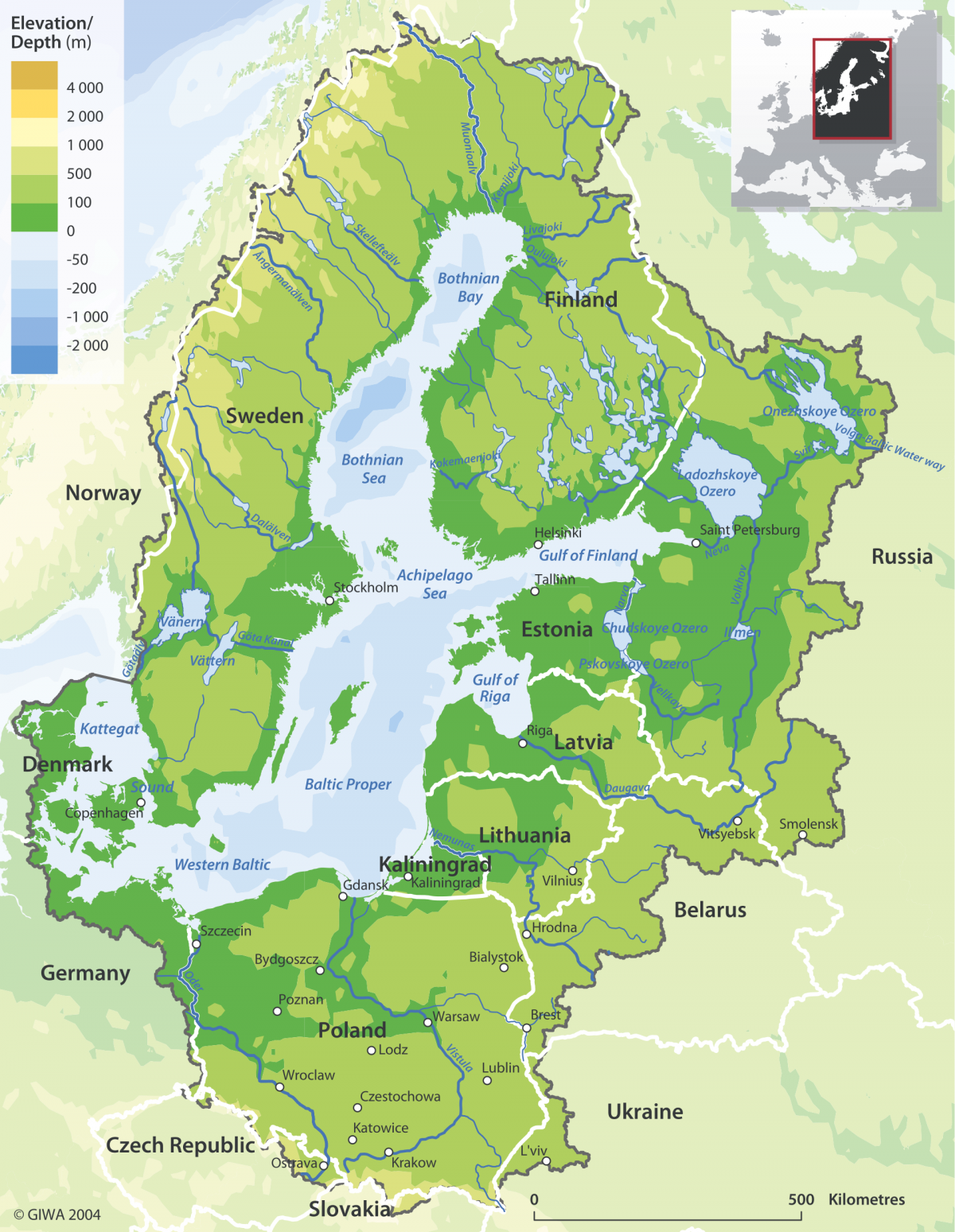
The Baltic Sea is a pool of water accumulating from an area of nearly 2000 square kilometers. In the west the sea’s drainage basin encompasses almost the whole of Sweden, half of Denmark, and parts of Northern Germany, whereas the basin’s eastern edge encircles the Lake Onega and Ladoga – expanding beyond the borders of the EU. In north, the drainage basin reaches the Inari Lake – one of the least populated and ecologically pristine areas of Europe. In south, there is Poland and parts of Slovakia, the Czech Republic, and last but not the least Ukraine, where a historically significant war rages on next to Central Europe. Coastal but also inland countries belong to the drainage basin, like Belarus that is led by the sovereign leader Alexander Lukashenko. [1, see Img 1]
A set of warped and twisted lines reach out to the sea from the land. Streams and rivers carry excess fertilizers, toxins, and organic material from inland sites of agriculture, forestry, industry, and residential living. The waste waters of 85 million people make the shallow sea the world’s most polluted. [Img 1]
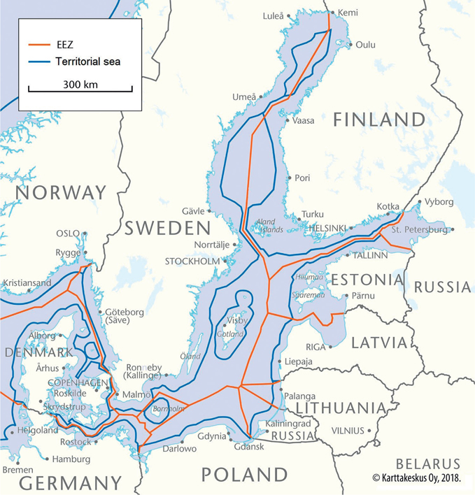
Taking a look at the map reveals another set of lines around countries. They have been drawn into water. Territorial state borders and exclusive economic zones chop the Baltic sea into pieces. So called “no man’s sea” opens up in the middle of the Gotland Basin and the Gulf of Bothnia, but accessing the Baltic Sea from the Atlantic requires an entry to Sweden’s or Denmark’s waters, since the Øresund strait falls fully inside the two states. The majority of the Baltic Sea is someone’s backyard despite that water molecules and biological organisms travel across borders and there is no firm ground in the sea surface to stick a flagpole into. [Img 2]
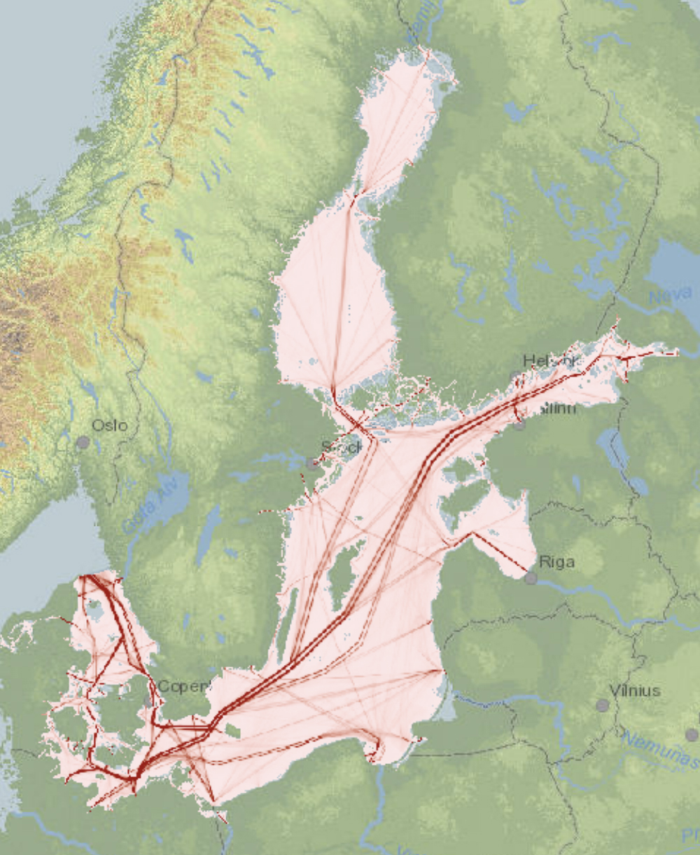
The surface of the sea is filled with smaller lines – or lanes. Shipping lanes act as directors of movement in the sea. They conduct an administrative logic that seeks to ensure maritime security. Cargo ships, fuel tankers, military vessels, and passenger crafts traveling within the lanes follow the rules of the game. All is well when everything in the system goes as planned. However, once in a while navigation fails – causing a deviation from the system of maritime security that is a lifeline to countries whose supply relies on maritime logistics. [Img 3]
In the air, lines are drawn over the water. As a result of Russia’s recent attack on Ukraine, banning Russian aircrafts from using the EU airspace has forced them to fly over the international waters of the Baltic Sea. The air above the Baltic Sea’s international waters has become sort of a highway to St. Petersburg and Moscow [see 2]. Transponderless military aircrafts have caused hazardous situations in the area already in 2014. Such are invisible to the traffic administration in the area. [3]
Below the surface numerous infrastructures crisscross the sea. Finland’s international internet traffic used to travel through Sweden in a telecommunications cable. Now there are cables to Germany. Powerlines cross the sea too, as the Nordic and Baltic electricity networks have been integrated. And the gas networks are partially connected. These issues have been recently discussed due to the Nord Stream case. [4]
The Nord Stream pipelines supplied natural gas to Germany from the peripheries of West Siberia, thus connecting the Baltic Sea to extractive regions originally inhabited by indigenous Nenets, Khanty, and Mansi. Their cultures have become threatened by extensive industrialization of the tundra that global warming has made possible [5].
Where the Nord Stream does not run is just as interesting. Building the pipelines allowed Russia to bypass the territory of Ukraine and Belarus, from where the old Soviet gas infrastructure crossed border to the West. Thus, the Nord Stream meant less geopolitical leverage for those two countries [6]. Despite this fact, Nord Stream was never about geopolitics, social justice, risking the climate, or even security for western European governments – but cheap energy.
When complex, or just irregular, phenomena are forced into a model, the margin of error increases. Important factors and pieces of information become left out or get distorted. In Finland, the political decision of allowing the Nord Stream to be constructed in the country’s economic zone was let to be considered only as an environmental question, since the pipelines’ ends were in somewhere else [7]. As I write this in October 2022, the broken pipelines release humongous amounts of methane into the atmosphere, but no-one is held responsible. The resulting effect on global warming is comparable to the yearly emissions of a small European country [8]. When something does not fit into a model, it is often seen as a deviation – a “force majeure” that could not be considered.
However, in complex systems, deviations are just questions of time. Some say that the risk of an oil catastrophe in the Baltic Sea is such. The region’s rugged landscape, shallow waters, challenging climatic conditions, and crowded international traffic make up a difficult ground to navigate. Recovering an oil spill is even harder. According to the theory of normal accidents by sociologist and Science and Technology Studies scholar Charles Perrow, events like this are inherent part of complex systems. There are just too many variables and possible chains of actions to consider, which is why improbabilities realize once in a while, no matter how much risk analysis is conducted [see 9]. Free flows of chemical pollution do not follow any drawings on water, but the ways of nature that we do not properly understand.
Notes
1. Jesper Andersen, Juris Aigars and Ulrich Claussen, “Development of tools for assessment of eutrophication in the Baltic Sea”, Baltic Sea Environment Proceedings 104 (2006).
2. AirNav, RadarBox, https://www.radarbox.com/@58.57768,14.52442,z5.
3. ABC News, “Russian jet flying without transponder nearly collided with passenger plane, Swedish authorities say”, ABC News, December 14, 2014, https://www.abc.net.au/news/2014-12-14/russian-jet-nearly-collided-with-passenger-plane-sweden-says/5965816.
4. Juha-Matti Mäntylä, “Suomen ainut suora datakaapeli Keski-Eurooppaan kulkee samaa reittiä kuin Nord Stream – verkkoyhtiö: “Välissä on useita satoja metrejä””, Yle Uutiset, September 29, 2022, https://yle.fi/a/3-12643389.
5. Bruce Forbes, Florian Stammler, Timo Kumpula, Nina Meschtyb, Anu Pajunen and Elina Kaarlejärvi, “High resilience in the Yamal-Nenets social–ecological system, West Siberian Arctic, Russia”, PNAS 106, no. 52 (2009). https://doi.org/10.1073/pnas.0908286106.
6. Mark Temnycky, ”The Security Implications of Nord Stream 2 for Ukraine, Poland, and Germany”, Wilson Center, March 17, 2021, https://www.wilsoncenter.org/blog-post/security-implications-nord-stream-2-ukraine-poland-and-germany.
7. Samuli Vänttilä, “Vanhanen: Tästä syystä Nord Stream -kaasuputket käsiteltiin Suomessa ympäristökysymyksenä – “Jälkiviisaudelle on aina herkullinen sijansa””, Suomenmaa, October 10, 2022, https://www.suomenmaa.fi/uutiset/vanhanen-tasta-syysta-nord-stream-kaasuputket-kasiteltiin-ymparistokysymyksena-jalkiviisaudelle-on-aina-herkullinen-sijansa/.
8. Helsingin Sanomat, ”Nord Stream -putkien metaanipäästöt pelättyä pienempiä”, Helsingin Sanomat, October 5, 2022, https://www.hs.fi/ulkomaat/art-2000009116222.html.
9. Charles Perrow, Normal Accidents: Living with High-Risk Technologies (BasicBooks, 1984), 3–5.
Ecological Thinking
This is the course blog for KDOC-24B20 – Ecological Thinking Seminar. In 2024-25, the seminar collaborates with Helsinki Biennial 2025 contextualizing its themes and curatorial vision with discourses and practices in the visual and performing arts. In 2023-24, we explored “Vertical Ecologies” by visual arts, film and performance, co-organized with Curator Giovanna Esposito Yussif of the Museum of Impossible Forms. Previously, in 2022-23, we organized a year-long collaborative research studio with Aarhus University, DK, Research Pavilion 2023 and Helsinki Biennial 2023 on the themes of environmental data, sensing and contamination.
Header image credit: Abelardo Gil-Fournier and Jussi Parikka / Seed, Image, Ground (2020)- With permission from the authors.
Latest posts
Follow blog