Remote View to Geologic Formations of Mining Industry and Land Art
Heini Nieminen explores the links between mining and land art from the perspective of aesthetic and geological formations.
Heini Nieminen

“De Maria once said his favorite paint brush was the Caterpillar tractor” [2]
The influence/imprint of human, Anthropocene appears in several ways on Earth, one of the factors leaving behind a visible trace is mining industry. The connection between geology, mining and land art could be addressed from several perspectives. I’m trying to grope the link between mining and land art from the perspective of aesthetic and geological formations and the positions of perception to these visual sceneries.
According to Jussi Parikka (2015) already in land art—or earth works—emerging in the 1960s that one finds a significant investment in the articulation of the earth as part of the aesthetics of contemporary art. Such aesthetic practices become investigations concerning a relation with earth and its radical temporality; they refer to a situation of human involvement with the planetary and the irreducibility of the earth to its human inhabitants. [3]
Remote sensing or earth observation means gathering of information about planet Earth’s physical, chemical and biological systems with the help of remote sensing technologies, usually involving satellites carrying imaging devices. Earth observation is used to monitor and assess the natural and manmade environment. Space-based technologies transfer reliable and constant datasets, which combined with research and development of appropriate methods, offer a particular tool for gathering information concerning the planet. [4] Today mineral exploration is highly technologized and constitutes a colossal business. The mining industry as well weaves its web into outer space by remote sensing offered by thousands of satellites orbiting our planet at this moment. [5] Remote sensing dominates the field of mineral prospecting, exploration and extraction. It can be used in every phase of mining from the search for mineral resources and deposits to extraction, mine closure and reclamation. Ground based surveying is still in use in mining operations but the increased availability of imagery from spaceborne satellites and airborne platforms has resulted in a significant increase in the use of remote sensing imagery. [6]
Besides mining earth observation is used in several fields from military use to climate change research and surveillance. It has it’s imprint on art as well. Remote sensing produces stunningly beautiful imagery if considering them only as “pure” images and putting aside the “extractive view” of the action. [7] In addition to this image use of remote sensing in art, satellites offer a possibility to experience a distanced view to large-scale land art pieces that are difficult of even impossible to perceive from the perspective of a human eye.
The most large-scale land art pieces such as Michael Heizer’s City 800mx2400m (1970-2022) [8] or Double Negative width 9m, depth 15m, length 457m (1969) [9] or Robert Smithson’s, Spiral Jetty, 4572m×457.2m (1970) [10], seem challenging to perceive comprehensively. You can be inside/on them or look at them from the distance but it’s difficult to see these massive pieces entirely with bare eye from the ground. Distance and the remote eye, drone, airplane or satellite can offer the view to see the enormity of these works.
While I look at the remote sensing imagery or on-site view of a mine, there comes moments when the aesthetics take over the ethics. Few times I have stood on the edge of the open mine in Pargas, Finland and I couldn’t help but to admire the view. The enormity and precision of this excavation transformed the mine into an artwork. If concentrating on the form, the colors, the size, and the relations of these to each other and let yourself immerse in the formalistic point of view, it’s easy to enjoy the scenery. For a split second the impressive view pushes aside the knowledge of negative effects of mining industry. The contradiction, between the visually pleasing view and the negative facts behind it, is difficult to contemplate. The border between an artwork and a mine is being blurred.
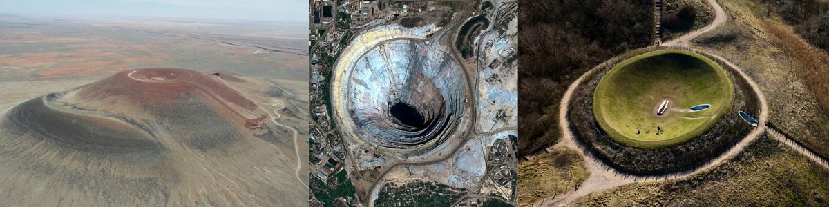
Roden Crater, is a large-scale artwork created within a volcanic cinder cone by artist James Turrell located in Arizona, USA, representing the artist’s lifelong research in the field of human visual and psychological perception. The first major phase of construction included the moving of over 1.3 million cubic yards of earth to create the Crater Bowl and the shaping of the 854′ East Tunnel. The construction on Roden Crater is ongoing. [16] The Mir Mine is an inactive, open-pit diamond mine located in Mirny, Eastern Siberia, Russia. The mine is 525 m deep and has a diameter of 1200m. This makes it one of the largest excavated holes in the world. [17] Celestial Vault was built in 1996 by James Turrell in The Hague, Netherlands. The Celestial Vault is a monumental earthwork constructed to resemble a large crater. The idea is for visitors to lie on the bottom of the work with their heads towards the lower ends of the slopes which will allow them to see the edge of the crater but mainly the open sky. [18] If standing on the edge of Roden Crater, Mir Mine and Celestial Vault how could I make a distinction between these three (or distinct the one from the two) if thinking of them as formalistic sculptures? Or has time passed me by and I’m not allowed to look at them from this perspective?
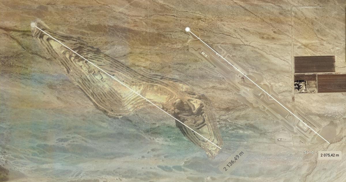
Even though remote sensing provides an easily available distanced view to this scale of works, when circling them as 2d and 3d versions in Google Earth [19] I notice the problem of technology and remote sensing. Even if I see the measurements of the geological formations, I don’t understand the scale when not experiencing views on-site with my own eyes. The man-made imprint on the Earth is perhaps impossible to fully comprehend via satellite imagery when it comes to the enormity of environmental damage by mining industry or the monumentality of land art. The machine-eye can’t replace the experience what a human eye can offer.
Notes
- NASA, Image Copyrights, 2021, https://svs.gsfc.nasa.gov/vis/a030000/a030000/a030065/earth_current_missions_dates_print.jpg
- Land Art, Art Beyond the Gallery / July 4, 2020 https://www.geoffharrisonarts.com/blog/tag/Walter+De+Maria
- Parikka, Jussi, Earth Forces, Contemporary Land Arts, Technology and New Materialist Aesthetics. Cultural Studies Review volume 21 number 2 September 2015 pp. 47–75
- https://joint-research-centre.ec.europa.eu/scientific-activities-z/earth-observation_en
- The number of satellites vary depending on the source from 6500 to almost 7500.
- PCI Geomatics, “Mining Exploration and Remote Sensing Imagery”. Geo-matching.; https://geo-matching.com/content/mining-exploration-and-remote-sensing-imagery
- Concept used by Gökçe Önal referring to Macarena Gómez-Barris in Media Ecologies of the ‘Extractive View’, : Image Operations of Material Exchange, 2020; Example of remote sensing image: http://www.geoanalysis.eu/6en_remotesensing_gis_laser_spectral_mineral_exploration.html
- https://en.wikipedia.org/wiki/City_(artwork)
- https://en.wikipedia.org/wiki/Double_Negative_(artwork)
- https://en.wikipedia.org/wiki/Spiral_Jetty
- https://en.wikipedia.org/wiki/City_(artwork)
- https://yle.fi/a/3-9813598; https://www.nordkalk.com/about-us/our-locations/finland/pargas/ Main products: limestone, limestone powder, quicklime, aggregates.
- Image copyright: https://www.geoffharrisonarts.com/blog/tag/James+Turrell
- Image copyright: https://dailyoverview.com/overviews/mir-mine
- Image copyright Siebe Swart, https://www.stroom.nl/gfx/uploads/23277_webSMS_20090320_0276.jpg
- https://rodencrater.com/about/
- https://dailyoverview.com/overviews/mir-mine
- https://www.siebeswart.nl/image/I0000t3Pa3WrgvpU
- Google Earth is a map service that combines satellite and aerial images and location data to form a three-dimensional image of the Earth. Google Earth’s material is not constantly updated, so the images may be several years old. https://earth.google.com/web/
Ecological Thinking
This is the course blog for KDOC-24B20 – Ecological Thinking Seminar. In 2024-25, the seminar collaborates with Helsinki Biennial 2025 contextualizing its themes and curatorial vision with discourses and practices in the visual and performing arts. In 2023-24, we explored “Vertical Ecologies” by visual arts, film and performance, co-organized with Curator Giovanna Esposito Yussif of the Museum of Impossible Forms. Previously, in 2022-23, we organized a year-long collaborative research studio with Aarhus University, DK, Research Pavilion 2023 and Helsinki Biennial 2023 on the themes of environmental data, sensing and contamination.
Header image credit: Abelardo Gil-Fournier and Jussi Parikka / Seed, Image, Ground (2020)- With permission from the authors.
Latest posts
Follow blog